This article is more than
3 year oldGoogle Earth time-lapse feature winds clock back 37 years
The feature uses millions of satellite images from the past 37 years to let people scroll through time.
It allows people to see, for example, the retreat of glaciers alongside global warming, or the deforestation of the Amazon over time.
The company says it is the biggest update to Google Earth in four years.
Google Earth uses similar technology to the widely used Maps product, but is more focused on geology and exploration than public transport and directions.
Users can access the tool in a web browser, and the feature comes with some pre-packaged virtual tours of an Alaskan glacier melting over the years or forest protection efforts in Brazil.
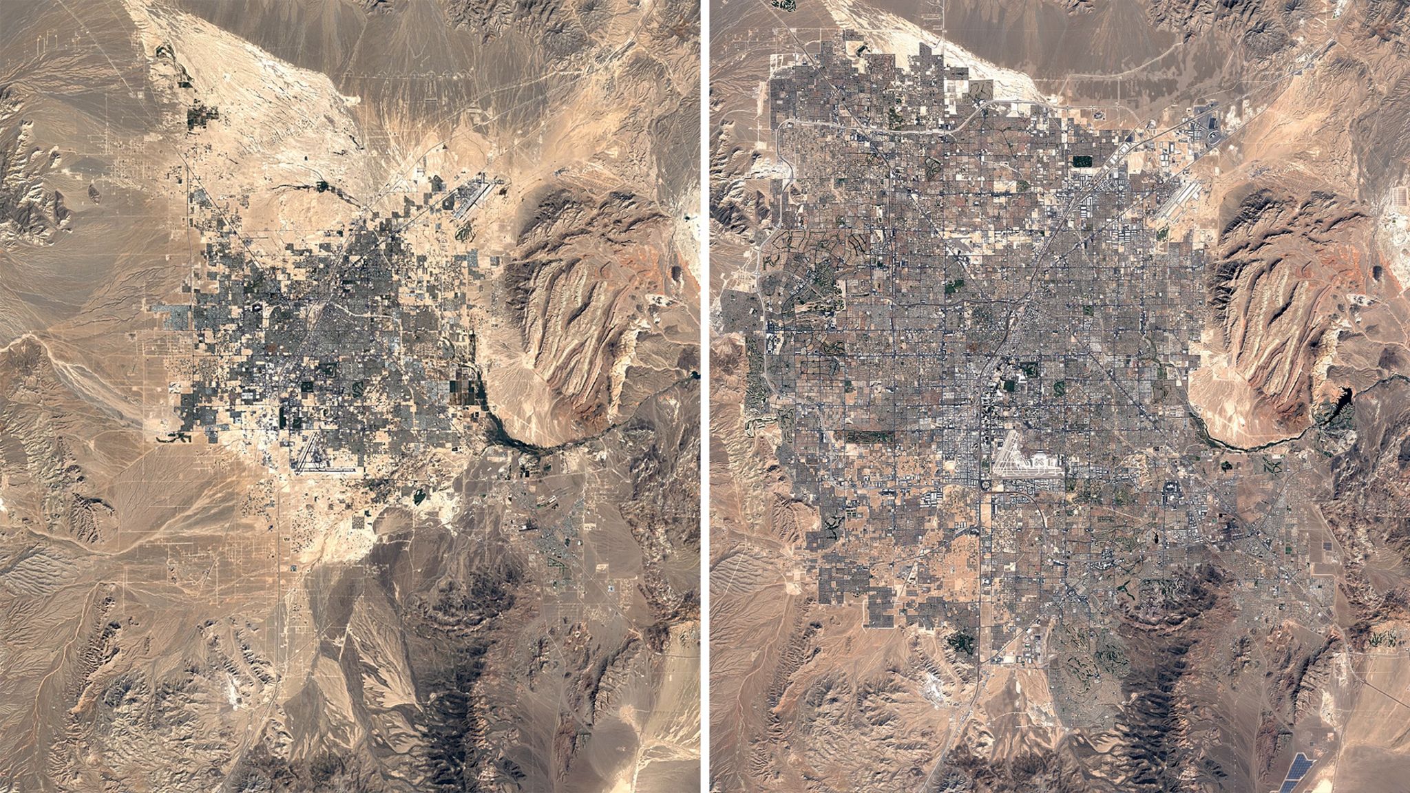
Las Vegas, Nevada, 1984 and 2020
But the time-lapse feature is global - meaning users can just type in any location and experiment with whatever images are available.
Google is heavily marketing the tool as a way to raise awareness of climate change and other environmental issues.
It pointed to the shifting sands of Cape Cod and the drying of Kazakhstan's Aral Sea as striking examples of how the landscape is changing.
But it also documents the boom in towns and cities across the world - from the rapid expansion of Las Vegas to the building of artificial islands in Dubai.
"We have a clearer picture of our changing planet right at our fingertips - one that shows not just problems but also solutions, as well as mesmerisingly beautiful natural phenomena that unfold over decades," Google said.
An Earth-sized video
Under the hood, the new version of Google Earth is powered by 24 million different satellite photos, from Nasa, the US Geological Survey's Landsat project, and the EU's Copernicus project.
Google said the new features "simply wouldn't have been possible" without the "commitments to open and accessible data" from those space agencies.
While the average user will only see a tiny fraction of the system at a time, Google says the animated time-lapse imagery is essentially one giant video mosaic, made up of individual video tiles.
The 24 million images date back as far as 1984, and take up 20 petabytes - 20 million gigabytes - of storage space, and "quadrillions of pixels", the company said.
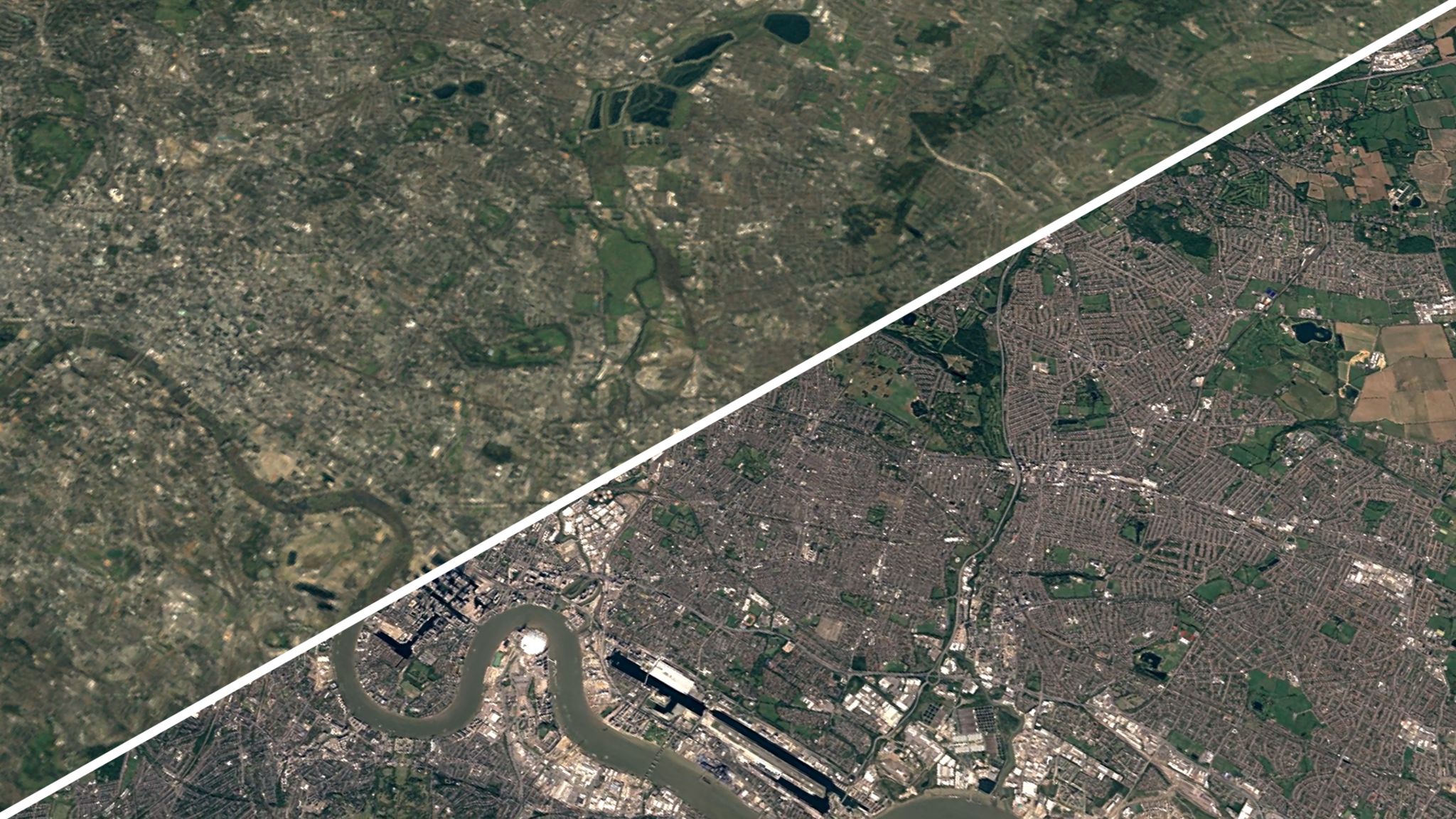
East London, 1984 and 2020, looking from Canary Wharf towards the Olympic park
Together, they make one single video 4.4 terapixels in size - something Google said is the equivalent of more than half a million 4K ultra-high-resolution videos.
Processing all that data took more than two million hours of computer time - shared among thousands of high-powered machines owned by Google to get the job done in a reasonable timeframe.
- Google reveals travel habits during the pandemic
- Google Maps to start showing eco-friendly routes
- Microsoft puts the entire world in Flight Simulator
"As far as we know, time-lapse in Google Earth is the largest video on the planet, of our planet," the company said.
That kind of heavy processing in air-conditioned data centres uses vast amounts of power, and has a significant environmental impact. Google argues that all its data centres are carbon neutral, though it does this through the practice of offsetting - paying for environmental projects to "balance" its use of energy.
The huge amount of historical data also has other practical benefits - such as removing clouds. Any one set of photos from the Earth's surface will have areas obscured by cloud cover that the satellite can't see.
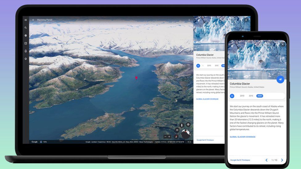
Google has prepared virtual tours - such as this Alaskan glacier - to showcase climate issues
But over time, different pockets become visible, which can then all be stitched together to form a picture of what's underneath.
Google says it plans to update this new time-lapse project every year for at least the next decade.
"We hope that this perspective of the planet will ground debates, encourage discovery and shift perspectives about some of our most pressing global issues," it said.
Keywords


<p>Diddy's homes were recently raided in Los Angeles and Miami by Homeland Security.</p>
India calls for ‘immediate de-escalation’ amid Israel-Iran tensions
Why Israel is risking a dramatic escalation with Iran
Trump offers conditions for Ukraine aid renewal
Bianca Censori stuns in extreme v-neck dress
Israel’s War Leaders Don’t Trust One Another
US helped Israel take down ‘nearly all’ Iranian drones and missiles – Biden
Iron Dome, David’s Sling, Arrow: Israel’s air defense against Iran, explained
‘Their tactics have changed’: Russia’s bid to blow apart Ukraine’s power grid
OJ Simpson to be cremated and no plans to donate brain to science, lawyer says