This article is more than
6 year oldTyphoon Jongdari: Weather-ravaged Japan braces for powerful storm
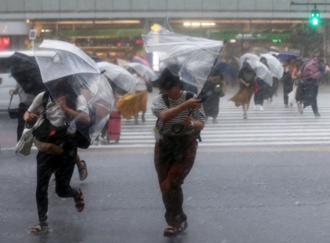
Typhoon Jongdari (or "skylark" in Korean), is expected to make landfall on the country's main island, Honshu, late on Saturday or early on Sunday.
The storm comes less than a month after floods killed more than 200 people, and then a heatwave left dozens dead.
Japan's Meteorological Agency has told locals to be ready to evacuate.
At 20:40 local time (11:40 GMT) the category 1 Jongdari was situated about 200km south of Tokyo and forecast to make landfall close to the city of Nagoya.
The Meteorological Agency says as of 5 PM Saturday, Typhoon Jongdari was traveling west-northwest at 45 kilometers per hour near Miyake Island in the Izu Island chain.https://t.co/MlrsKyHlVw pic.twitter.com/DxqCSJtx53
— NHK WORLD News (@NHKWORLD_News) July 28, 2018
More than eight million people were ordered to leave their homes earlier in July when torrential rain saw rivers burst their banks, but some became trapped after failing to heed the order. Critics said the official warning came too late.
"We are afraid that people may not be able to evacuate due to strong wind or floods blocking evacuation routes," said Hiroshima's governor, Hidehiko Yuzaki.
"I would like people to evacuate in advance so that they can save their lives."
Evacuation advisories have been issued to 36,400 people in the western city of Shobara, and 6,300 in the city of Kure, Japanese media report.
'Double punch'
The prefectures worst hit by flooding were Okayama, Hiroshima and Yamaguchi, in the Chugoku region, and more than 4,000 survivors are still living in temporary shelters there.
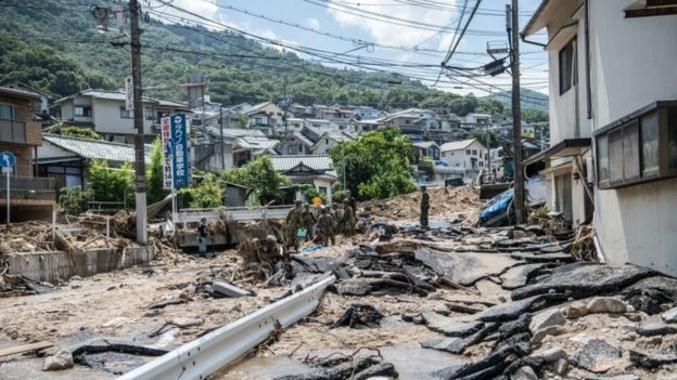
Soldiers clear roads on 10 July after landslides in Yanohigashi, near Hiroshima

"We are fully ready 24 hours a day to evacuate residents," Tadahiko Mizushima, an official in Okayama, told the AFP news agency.
"We are paying special attention to the areas where restoration of river banks is under way as it would be the first heavy rain since the disaster."
"It's going to deal a double punch," one Okayama man told Japan's public broadcaster NHK. "We are seriously worried."
Sandbags are being rapidly deployed as barriers against the feared flooding.
Images already show sizeable waves off the coast south-west of Tokyo, and ferry services are suspended. Forecasters say the area around the capital could see 40cm (15in) of rain in 24 hours from noon on Saturday.
The floods earlier in July were Japan's worst weather disaster in decades, and were swiftly followed by an unprecedented heatwave which has been declared a natural disaster.
The country is now in the grip of typhoon season, which sees tropical storms barrel across the Pacific throughout the summer months.
Keywords


Newer articles

<p>A bill that will ban TikTok in the United States unless its Chinese owner divests from the company has passed overwhelmingly.</p>
Congress gets closer to forcing TikTok to be sold or face US ban: What's ne
Israel Iran attack: Damage seen at air base in Isfahan
Ukraine ‘will have a chance at victory’ with new US aid, Zelenskyy says
Ukraine war: Kyiv uses longer-range US missiles for first time
Who will be Trump’s VP? A shortlist
House passes potential TikTok ban that could speed through Senate
Congress passes bill that could ban TikTok after years of false starts
How soon could US ban TikTok after Congress approved bill?
Finally, America’s Congress does right by Ukraine